


Solar Energy Potentials In Myanmar
This project was carried out under the collaboration on renewable energy
and energy conservation between Thailand and the Union of Myanmar. The
project was organized by Department of Alternative Energy Development and
Efficiency (DEDE), Thailand and Department of Meteorology and Hydrology
together with Department of Energy Planning of the Union of Myanmar, Solar
Energy Research Laboratory of Silpakorn University, Thailand was invited to
carry out the project. The main objective of this project is to investigate the solar
energy potential of the Union of Myanmar. In investigating the solar energy
potential, solar radiation incident on the entire area of the Union of Myanmar was
estimated by using a satellite-based solar radiation model. An 11-year period
(1998-2008) of satellite data from GMS5, GOES9 and MTSAT-1R satellites were
used as an input of the model. The scattering and absorption of solar radiation due
to clouds, water vapour and ozone, and the depletion of solar radiation by aerosols
were also accounted in the model parameterization. The reflectivity data obtained
from the satellites provide cloud information to the model. The absorption of solar
radiation due to water vapour was computed from precipitable water data. The
ozone data from the EP/TOMS and AURA/OMI satellites were used to compute
the absorption due to ozone. The depletion of radiation due to aerosols was
estimated from visibility data and the 5S radiative transfer model. For the model
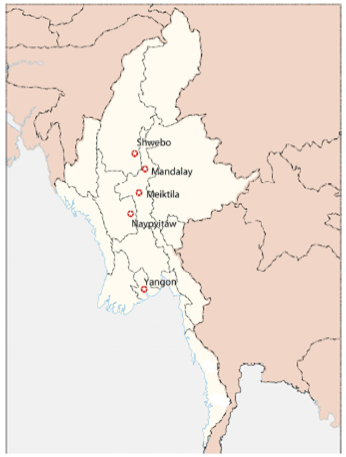
validation, solar radiation monitoring stations were established at 5 locations in
Myanmar, namely Yangon, Naypyitaw, Meiktila, Mandalay and Shwebo. Solar
radiation data obtained from these stations were used to compare with those
calculated from the model. In addition, the comparisons were also performed with
the measurement data collected from 10 stations in Thailand. These are Chiang
Mai, Chaing Rai, Doi Muser, Mae Sariang, Kanchanaburi, Thongphaphum,
Nakhon Pathom, Prachuap Khiri Khan, Chumphon and Ranong. The solar
radiation calculated from the model and that obtained from the measurement were
in good agreement with a root mean square difference (RMSD) of 8.9 %. After
the validation, the model was used to calculate monthly and yearly average daily
global solar radiation for the entire country and the results were displayed as solar
energy potential maps. The monthly maps show that the seasonal variation of
solar radiation is mainly affected by the monsoons and local geography. High
solar radiation is observed from February to May for most parts of the country.
From the yearly map, it can be seen that the central plain of the country including
Mandalay Division, Sagaing Division and Magway Division receive high solar
radiation (18-22 MJ/m2-day) for almost the whole year. The yearly average of
solar radiation for the entire country was found to be 18.3 MJ/m2-day. These
results indicate that Myanmar has a relatively high solar energy potential, which
can be utilized for various solar energy applications. Finally, a solar radiation
database was also developed for designing solar energy systems in Myanmar